An insurance provider sold a hail and wind damage insurance policy on a cornfield. When a severe hailstorm damaged the crop, the appraisal by the loss adjuster determined the grower should receive an indemnity payout of approximately $50,000. Could the inspection process have been improved?

The problem
In the aftermath of a hail event, insurance adjusters perform site visits to investigate claims, often taking samples to assess leaf defoliation and stand count reduction. Adjusters—particularly those managing large, geographically distributed portfolios—have limited time in the field: they may need to evaluate damage in consultation with the grower, or by sampling only from areas easily accessible from the road. As a result, appraisal findings don’t always reflect the true condition of the crop overall.
In this case, the field was assessed to receive a payout of $49,939, or $182.50 per acre—a 36.5% payout of the $500/acre coverage plan. This payout rate was determined from sampling that indicated a 30.1% loss due to leaf defoliation and a 6.4% loss due to stand reduction.
The solution
Ceres provides data-informed sampling plans for damage appraisals that more accurately reflect impacts to crop condition and health. Analysts compare high-resolution image data captured at optimal times before and after the peril event to precisely quantify the crop impact of an event and classify areas of the field as severely, moderately, or mildly damaged, in support of the policy agreement.
In this case, arbitrary sampling in portions of the field practical to access from roadways (see image labeled, "Conventional Sampling" ) resulted in an overrepresentation of damage—and especially of severe damage.
Error in conventional sampling plan
| Damage level | Proportion of adjuster's sampling area | Proportion of full field | Impact on claim |
| Severe | 55.8% | 31.4% | Severe damage is overrepresented by 24.4% |
| Moderate | 38.0 | 39.0% | Moderate damage is underrepresented by 0.7% |
| Mild | 6.9% | 30.6% | Mild damage is underrepresented by 23.7% |
Ceres’ alternative approach (see image labeled, "Data-Informed Sampling") uses an analysis of high-resolution aerial data developed according to policy adjustment guidelines. Adjusters are guided to specific sampling locations—still within areas practical to access from roadways—that are maximally representative of the field overall. The data-informed sampling plan indicates multiple possible sampling locations with severe, moderate, and mild damage to the crop.
The rapid response and aerial overview perspective enable Ceres to recommend the sampling locations most representative of the field overall. As needed, Ceres can limit the sampling area to suit conditions on the ground—for example, by indicating only sampling locations within easy reach of a roadway.
The outcome
Aerial data reveals that the conventional sampling approach overrepresented damage to the field. Strategic sampling from representative locations would have resulted in an estimated payout $16,480 lower, a savings to the insurer of more than $60/acre. In additional, both the adjuster and insured party would have saved time in the field and benefited from a more visual representation of crop damage.
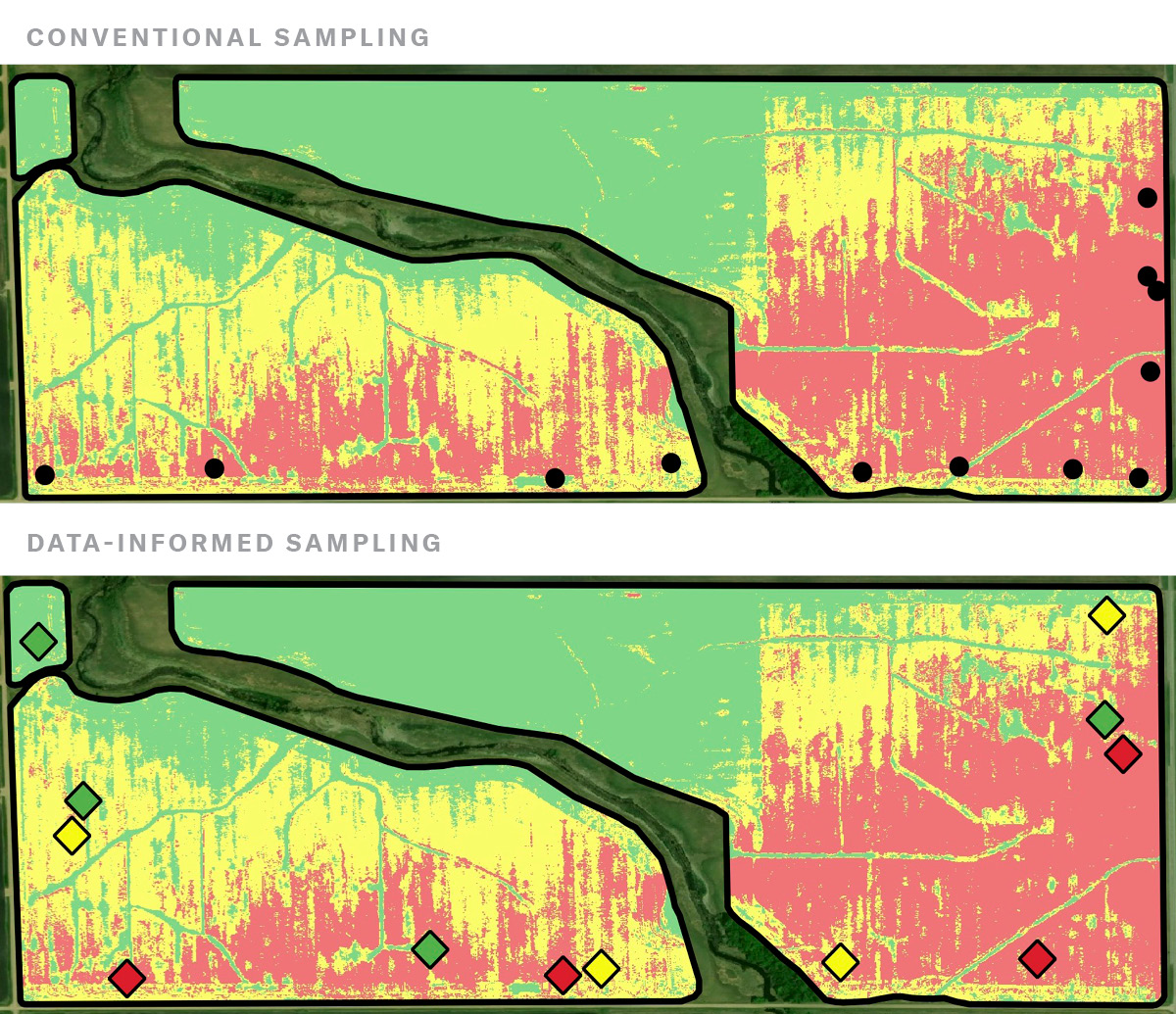
Image analytics from Ceres indicates areas of severe, moderate, and mild crop damage in red, yellow, and green, respectively.