Bullseye Farms is a family-owned farm dating back to the early 1900s. Focused on value and quality for their customers, Bullseye cares about fostering a healthy relationship between their crops and the environment in which they grow.
The problem
Bullseye Farms was already using Ceres Imaging to detect common drip system issues and guide irrigation strategy. But even the most well developed plan can be disrupted by changing conditions: when an intense heatwave hit Yolo County, the orchards lost pressure in key wells.
The irrigation manager needed to know exactly where to turn off valves in order to make the best possible use of the remaining water supply. Choosing incorrectly—or acting too slowly—could jeopardize the health of the crop.
The solution
The Bullseye team didn’t have time to go out and check soil across the entire orchard. Instead, the irrigation manager referred to his Water Demand Map from Ceres Imaging. By mapping the “thirstiest” parts of the field to their irrigation zones, he could quickly and easily prioritize the trees that needed water most.
“[When] we started to lose well pressure, my irrigators knew they might need to start turning off valves,” the irrigation manager explains. “I told them, ‘I have a map for that.’”
The irrigation manager felt confident relying on the Water Demand Map in this situation because the map uses Kc values custom to Bullseye’s fields. “When I get Kc values from a third party, I don’t know how they’re calculated—and they’re usually based on orchards that are different from mine,” he explains. “Because Ceres Imaging can accurately measure my canopy with their imagery, I trust the numbers they give me are customized to my trees. The variability we saw in Kc on the map matched what we were seeing in the field. Ceres allowed us to actually quantify, plan, and reduce water use without affecting the trees.”
The outcome
When water is scarce, Bullseye Farms uses Water Demand Maps from Ceres Imaging to quickly and precisely adjust irrigation scheduling—without risking the health of the crop.
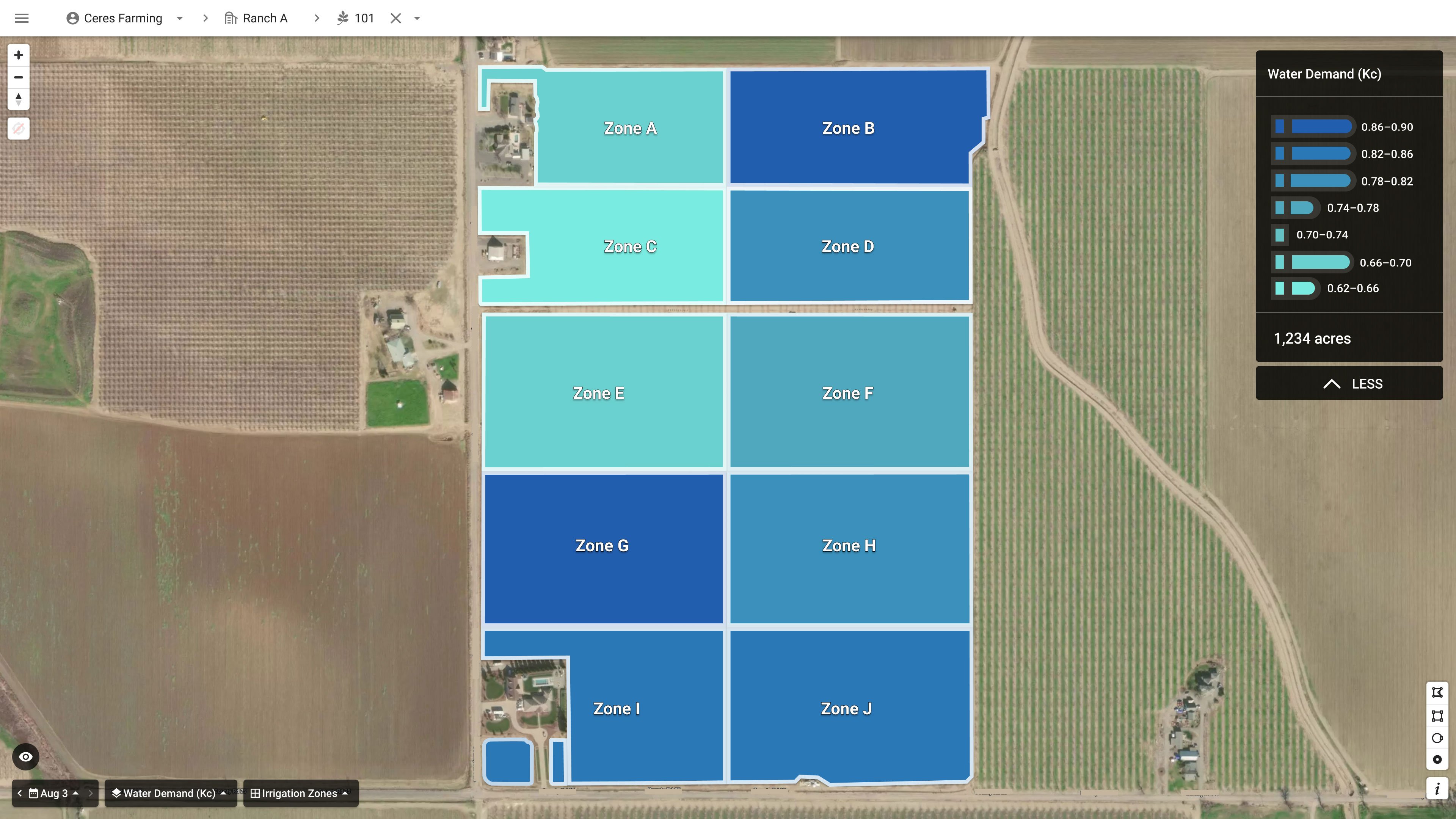
Growers like Bullseye Farms use Water Demand Maps to account for variability in canopy size, accurately calculating evapotranspiration rates—and optimal irrigation—across different areas of their fields.