
If the last time you thought about aerial imagery for agriculture was in the days of grainy satellite photos, you might be surprised to see what’s changed.
Today’s farmers benefit not only from improvements in remote sensing technology—such as highly precise thermal cameras—but also from powerful analytics tools made possible by machine learning. That means they aren't just looking at pictures any more: they're using data to guide their day-to-day decisions on the farm.
Here are four things you might not know farmers can do with aerial data.
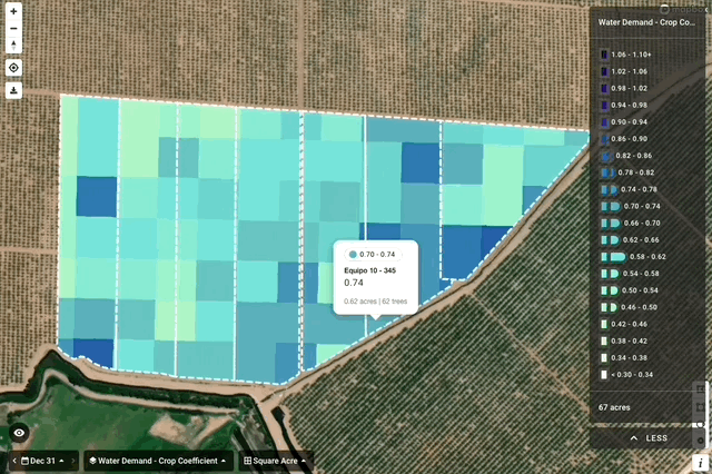
1. Choose where to prioritize limited water
When water's scarce, growers have to carefully select where, when, and how much to irrigate. In the past, that meant making estimations based on standardized measurements for the typical crop in their region. Now, growers can use Water Demand Maps to access data that's specific to their own fields—and view it by the acre, half-acre, or even irrigation zone.
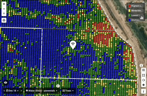
2. Check the performance of in-field sensors
Many growers use tools like moisture probes and weather stations to provide them with real-time, hyper-local information about conditions in their fields. But with sensor locations spread out over thousands of acres, it can be time-consuming to ensure they're always up and running. Fortunately, it's now possible to view sensor data and aerial imagery together, in context—making it easier both to interpret the sensor's information and to recognize when it might need service or maintenance.
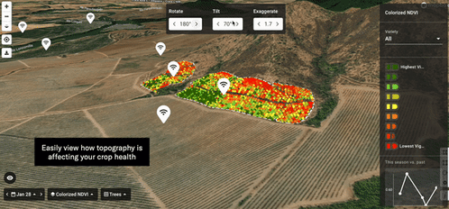
3. Spot where terrain is affecting crop health
Growers contending with hilly terrain have an extra set of challenges to contend with. Not only can soil depth and quality vary with elevation, some irrigation systems are prone to losing pressure and delivering insufficient water to crops upslope. Aerial imagery in 3D allows orchard and vineyard managers to visualize the impact of terrain on crop health down to the individual plant level.
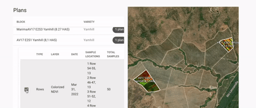
4. Pick the perfect sampling spots
Each season, vineyard operators use sampling to estimate anticipated grape yields. It's an important part of planning for the year, but it's a time-consuming and often error-prone process—especially with skilled vineyard workers in short supply. Now, growers can use aerial data to identify the most representative locations for taking samples, and generate a plan for collecting those samples efficiently.
To learn more about the surprising new ways growers are using aerial data on orchards, vineyards, and farms, check out customer stories from Ceres Imaging.