
Completely customizable solution raises the bar on accuracy, scalability, cost effectiveness
Ceres Imaging, the data analytics company that builds precision agriculture solutions to reduce risk and improve sustainability outcomes, today unveiled Water Recommendations. This new solution prescribes exactly how much water to apply every week for each irrigation zone, minimizing waste and maximizing grower profitability.
Ceres’ new Water Recommendations feature combines custom crop coefficients derived from aerial imagery with evapotranspiration forecasts to calculate the optimal number of inches of water to use. Data is tailored to specific fields, irrigation zones and local weather forecasts.
“From a bird’s eye view of a field, or drilled down to the level of an individual irrigation zone, the new Water Recommendations feature empowers Ceres customers with a closed loop solution that provides a highly accurate, cost-efficient and scalable guide for irrigation needs of plants in the coming week,” said Dr. Jennifer Strauss, senior technical product manager at Ceres.
Historical water usage can serve as guide for irrigation, but more dynamic data solutions are now needed amid water scarcity and the changing climate. Sensor companies that offer precision irrigation solutions calculate water requirements based on in-ground measurements, but they don’t capture field variability. So, these solutions may overestimate or underestimate water requirements for parts of the field that vary from the measurement location.
Ceres’ Water Recommendations takes a more targeted approach, providing customers with completely customized irrigation recommendations based on the actual water requirements of their plants as measured through Ceres’ water demand maps. These recommendations are more accurate, scalable and cost effective than competing precision irrigation solutions that rely on point measurements.
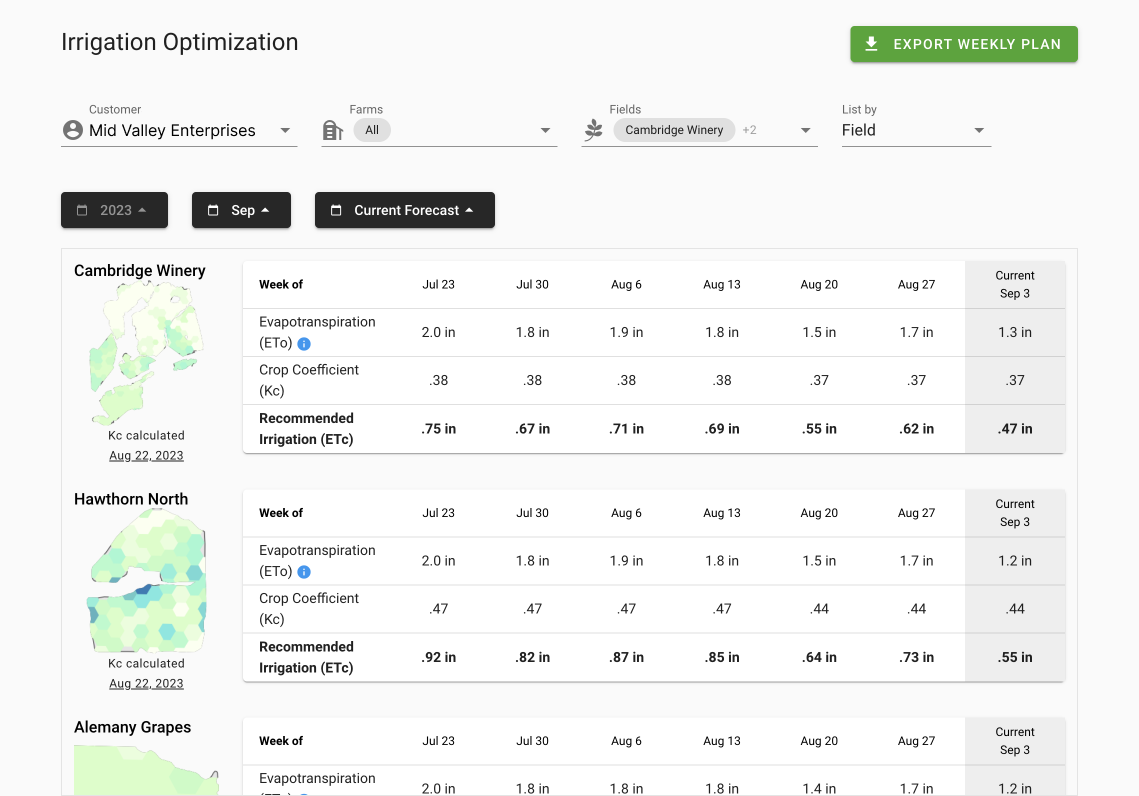
- The data table presents the evapotranspiration forecast for the coming week, the crop coefficient values from the most recent water demand map flight and a custom total evapotranspiration forecast in inches of water summed over a calendar week.
- The downloadable weekly plan enables growers to share forecast data easily with their irrigation teams.
- The linked water demand maps take growers to the flight overlay so that they can get a deeper understanding of the data presented.
The weekly summary of inches of water allows growers to better anticipate irrigation needs when ordering water. The linked water demand map enables growers to target water needs to plants that are less able to weather parched conditions, which is especially valuable when and where water is scarce. The custom recommendations that Ceres Water Recommendations delivers are particularly useful in the early season, or for young trees where canopy sizes are smaller, because Ceres calculates crop coefficients through a direct measure of fractional cover.
For more information, please visit our Sustainability Solutions, contact us for a free demo.